Super Typhoon Champi: Track, Strength and Impacts Explained
Champi, called Rosal in the Philippines, became a Category 5-equivalent super typhoon before brushing Guam and grazing Taiwan. Here is its track, how strong it was, what it did and where it is heading.
- Champi (Rosal) peaked on October 20, 2026, with JTWC-estimated one-minute winds near 296 km/h (185 mph); JMA put its 10-minute peak at 215 km/h.
- It passed about 10 miles south of Guam and grazed Taiwan without making landfall; Taiwan reported one death and more than 600 injuries.
- As of October 26, it has weakened to a fading tropical storm near southern Japan and is expected to become extratropical.
Super Typhoon Champi, known in the Philippines as Rosal, peaked on October 20, 2026, with one-minute sustained winds near 296 km/h (185 mph), making it a Category 5-equivalent storm and one of the strongest on Earth this year, The Weather Network reported. It passed just south of Guam, stayed offshore from the northern Philippines and grazed Taiwan, where one person died and more than 600 were injured. As of October 26, 2026, Champi has weakened into a fading tropical storm near southern Japan.
How Champi formed and intensified
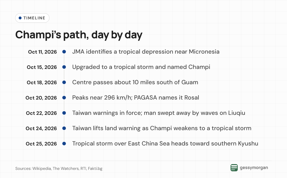
The Japan Meteorological Agency (JMA) first identified a tropical depression near Micronesia on October 11. The US Joint Typhoon Warning Center (JTWC) designated it 29W on October 14, and JMA named it Champi when it became a tropical storm on October 15, according to the storm's Wikipedia record, which compiles agency advisories. Laos contributed the name, which refers to a flowering tree, the list of storms named Champi notes.
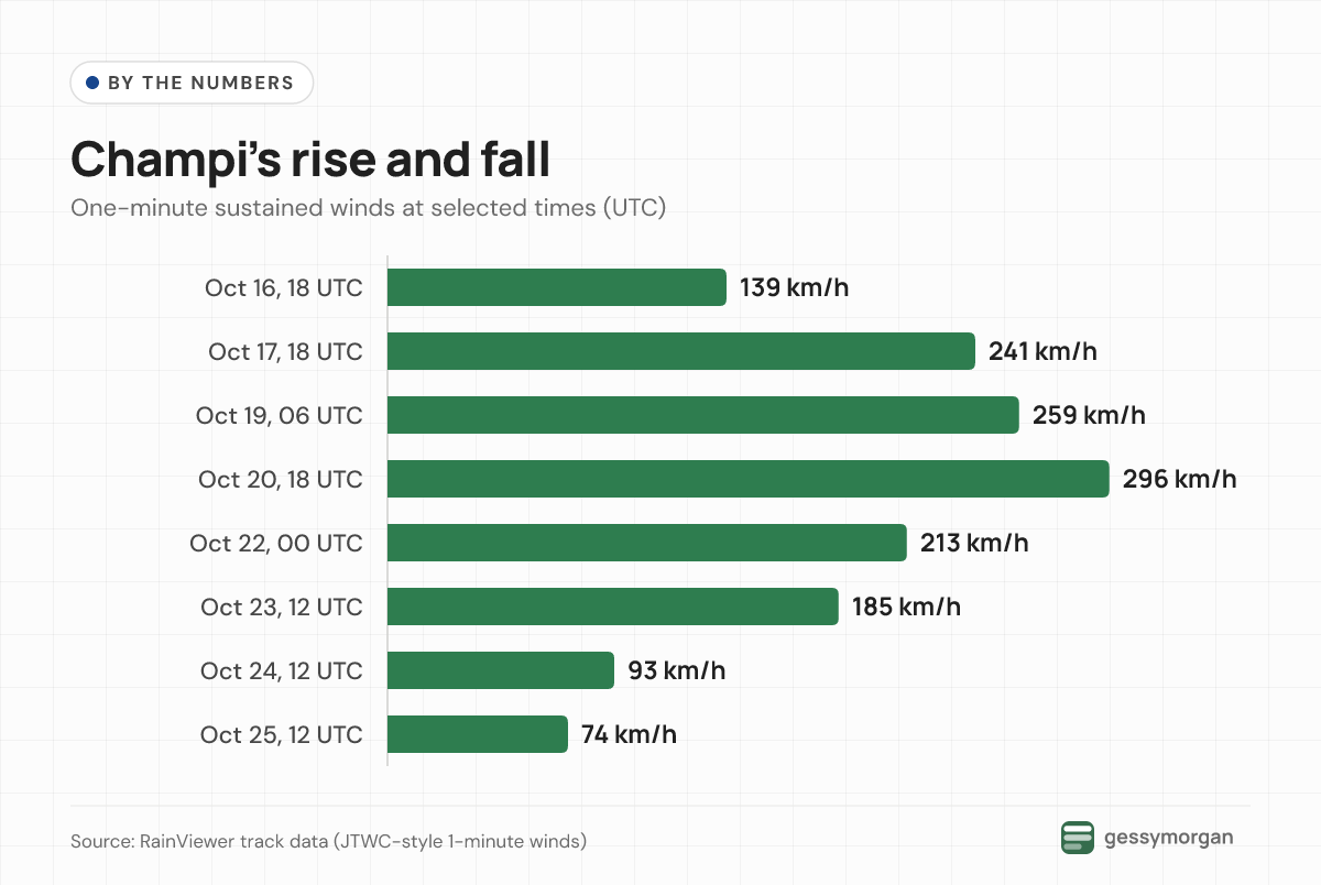
Rapid intensification began on October 16. By late October 17 (UTC), Champi was a Category 5-equivalent super typhoon near Guam. An eyewall replacement cycle briefly weakened it, but it re-strengthened over the Philippine Sea and peaked late on October 20 (UTC), east of the Philippines, at about 296 km/h with central pressure near 895 hPa, according to RainViewer's track data.
Conditions were close to ideal, with sea surface temperatures near 30°C, deep moisture and low wind shear, The Weather Network said. EU Copernicus Marine Service data showed significant wave heights of up to 10 metres near the centre on October 21.
How strong was Champi? It depends on the agency
Agencies report different peak winds for the same storm because they average wind over different periods. Here is how the main estimates compare:
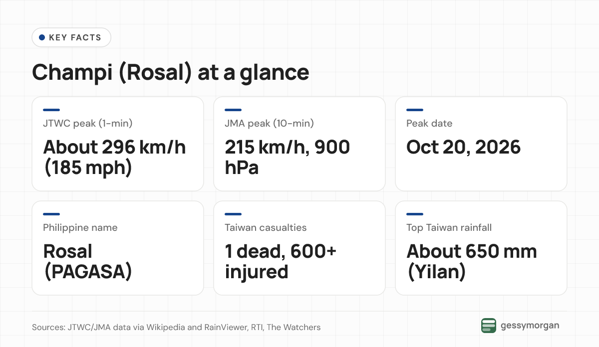
- JTWC uses one-minute sustained winds. Its peak estimate was about 185 mph (295 to 296 km/h), with pressure of 894 to 895 hPa.
- JMA uses 10-minute winds. It classed Champi as a "violent typhoon," peaking at 215 km/h (130 mph) and 900 hPa.
- PAGASA, the Philippine weather agency, gave sustained winds of 205 km/h and gusts of 250 km/h at 5 p.m. local time on October 21, The Watchers reported.
- Taiwan's Central Weather Administration (CWA) put it at 209 km/h and 900 hPa at 2 p.m. local time the same day.
Whether Champi was the year's strongest storm also depends on the measure. Copernicus described its winds as the strongest sustained winds of any tropical cyclone worldwide in 2026. Fox Weather and Yahoo News said it tied Super Typhoon Sinlaku, which set the mark in April. The Weather Network noted that eastern Pacific Hurricane Polo had lower central pressure (892 mb) and counted Champi as the world's seventh Category 5-equivalent storm of 2026.
Track and areas affected
Guam and the Mariana Islands
Champi's centre passed about 10 miles (16 km) south of Guam's southern tip early on October 18, local time, The Watchers reported. Guam's airport recorded gusts near 80 mph. Power outages were widespread, especially in the south, but there was no island-wide blackout. Governor Lou Leon Guerrero reported minimal damage, according to Fox Weather.
The Philippines
PAGASA gave the storm the local name Rosal on October 20 as it approached the Philippine Area of Responsibility. It raised Wind Signal No. 2 over Batanes and Signal No. 1 for parts of Cagayan, Isabela, Ilocos Norte, Apayao and Catanduanes, and warned of waves up to 10 metres off Batanes. The storm's core stayed offshore, and the Coast Guard suspended affected sea trips from Catanduanes.
As of October 26, PAGASA's bulletin page lists 17 bulletins for Rosal and shows no active tropical cyclone inside the Philippine Area of Responsibility.
Taiwan
Champi did not make landfall in Taiwan. Its centre passed near Nanfang'ao in Yilan, but the CWA ruled that it did not cross the coast, The Watchers reported. The Associated Press, in a report carried by weather.com, described the storm as grazing the island. Its large size still affected most of Taiwan from October 22 to 24.
- Casualties: One man died after waves swept him off a beach in Liuqiu Township, Pingtung County, on October 22. Taiwan's Central Emergency Operation Center counted 616 injuries on October 24, most of them minor, Radio Taiwan International reported. Its final briefing that night put the total at 634. A search was also under way for a man swept into the sea while fishing at Keelung on October 24.
- Rain: Yilan County recorded about 650 mm from Thursday to Saturday afternoon. Taoyuan and Hsinchu topped 500 mm, and Taipei received nearly 470 mm.
- Power and travel: Reported outages range from about 280,000 households (AP) to more than 340,000 (Fakti.bg, citing Taiwanese media). Taoyuan International Airport cancelled 563 flights on Friday and 261 on Saturday.
- Damage: More than 9,000 damage reports were filed, led by fallen trees, with Taipei City recording the most.
Taiwan lifted its land warning at 2:30 p.m. on October 24 and its sea warning that evening.
Japan's Ryukyu Islands
Champi's eyewall came very close to Yonaguni on October 23 before the storm made a loop east of Taiwan and turned northeast. Reported effects in Okinawa Prefecture included power cuts and flight suspensions at Miyako and New Ishigaki airports.
Which agencies tracked Champi
- JMA (Japan): named the storm and issued 10-minute intensity estimates.
- JTWC (US military): numbered it 29W and issued warnings using one-minute wind estimates, including the late forecasts for its final track.
- PAGASA (Philippines): assigned the local name Rosal and issued wind signals and gale warnings for northern Luzon.
- CWA (Taiwan): issued sea and land warnings, while the Central Emergency Operation Center reported casualties and damage.
- Korea Meteorological Administration: forecast rain for southern South Korea and Jeju as the storm's remnants moved north.
- National Weather Service, Guam: covers the Marianas. Its Guam office website listed no active tropical cyclones on October 26.
Forecast: what happens next
JTWC's warning on October 25 placed Champi over the East China Sea as a tropical storm with winds near 83 km/h, moving northeast. It expected the system to reach southern Kyushu and become extratropical around October 26, or to break down into a trough. RainViewer's latest data, from 00:00 UTC on October 26, showed winds near 65 km/h about 71 km off Japan.
The remaining risks are mainly rain and rough seas rather than destructive winds. As of October 25, the CWA expected occasional rain in eastern Taiwan, heavier in Hualien and Taitung. People in southern Japan and South Korea should follow JMA and the Korea Meteorological Administration for local warnings, and Philippine residents can check PAGASA.
Our take
Based on the agency data and reports cited here, Champi was a near-record storm at sea whose most violent core largely missed land. Guam and Taiwan both avoided a direct landfall. Even so, Taiwan's injury count and rainfall show that a very large storm can cause widespread disruption without its eye crossing the coast.
The spread in reported peak winds reflects different measuring methods rather than errors, so it is worth checking which agency a number comes from before comparing storms. For other science news this week, see our explainer on the October 2026 Hunter's Moon and Orionids.
Frequently asked questions
How strong was Super Typhoon Champi?
JTWC estimated peak one-minute sustained winds of about 185 mph (296 km/h) on October 20, 2026, equivalent to Category 5. JMA, which uses 10-minute winds, put the peak at 215 km/h with a central pressure of 900 hPa.
Did Typhoon Champi make landfall in Taiwan?
No. Its centre passed near Nanfang'ao in Yilan County, but Taiwan's Central Weather Administration ruled it did not make landfall. Its large circulation still brought heavy rain, strong winds and high waves to most of the island.
What is Champi called in the Philippines?
The Philippine weather agency PAGASA named it Rosal when it approached the Philippine Area of Responsibility on October 20. PAGASA raised Wind Signal No. 2 over Batanes, but the storm stayed offshore.
Where is Typhoon Champi now?
As of October 26, 2026, Champi is a weakening tropical storm near southern Japan. JTWC expected it to become extratropical around October 26 or break down into a trough. Check JMA for the latest local warnings.
Why do agencies give different wind speeds for Champi?
JTWC averages winds over one minute, while JMA uses a 10-minute average, which produces lower numbers for the same storm. PAGASA and Taiwan's CWA issue their own estimates too, so figures differ even when the agencies agree on the storm's strength.
Sources
- Typhoon Champi (2026), Wikipedia
- List of storms named Champi, Wikipedia
- 296 km/h: Super Typhoon Champi is now the strongest storm on Earth in 2026, The Weather Network
- Super Typhoon Champi becomes the strongest tropical cyclone of 2026, Signal No. 2 remains over Batanes, Philippines, The Watchers
- Typhoon Champi leaves one dead and hundreds injured as recovery continues in Taiwan, The Watchers
- Super Typhoon Champi generates 10-metre waves east of the Philippines, EU Space / Copernicus
- Typhoon Champi leaves 1 dead, over 600 injured, Radio Taiwan International
- Pacific eyes first V-named storm since 2018 as Super Typhoon Champi reaches 185 mph, Fox Weather
- Champi kills 1 and injures 350 in Taiwan overnight, The Weather Channel (weather.com) / AP
- Super Typhoon Champi becomes one of 2026's strongest storms as it heads toward Taiwan and eastern China, Yahoo News
- Tropical Storm Champi Tracker: Live Path & Location, RainViewer
- Tropical Cyclone Bulletins (Rosal), PAGASA
- Typhoon Champi kills, injures 616 in Taiwan, Fakti.bg
- National Weather Service Guam, NOAA National Weather Service
How we wrote this
GessyMorgan explainers are built from public reporting and official sources. This post draws on the 14 sources listed above, each linked where we use it. It was drafted with AI assistance and checked against those sources before publishing. We did not test products, attend events or interview anyone for this article. Facts are current as of October 26, 2026, and we update the post when they change.